The easy way
When working with the built-in Coordinate Reference Systems, PHPCoord can usually convert the
coordinates in any given Point to be in a different system by calling the convert() method.
$newPoint = $point->convert(
    CoordinateReferenceSystem $to,
    bool $ignoreBoundaryRestrictions = false
); // returns a new Point
Examples:
<?php
use PHPCoord\CoordinateReferenceSystem\Geographic2D;
use PHPCoord\CoordinateReferenceSystem\Projected;
use PHPCoord\Point\GeographicPoint;
use PHPCoord\UnitOfMeasure\Angle\Degree;

// Converting from NAD83 to Florida State Plane
$from = GeographicPoint::create(
    Geographic2D::fromSRID(Geographic2D::EPSG_NAD83),
    new Degree(28.46),
    new Degree(-80.53),
    null
);
$toCRS = Projected::fromSRID(Projected::EPSG_NAD83_FLORIDA_EAST);
$to = $from->convert($toCRS); // $to instanceof ProjectedPoint
<?php
use PHPCoord\CoordinateReferenceSystem\Geographic2D;
use PHPCoord\CoordinateReferenceSystem\Projected;
use PHPCoord\Point\ProjectedPoint;
use PHPCoord\UnitOfMeasure\Length\Metre;

// Converting from Florida State Plane to NAD83
$from = ProjectedPoint::createFromEastingNorthing(
    Projected::fromSRID(Projected::EPSG_NAD83_FLORIDA_EAST)
    new Metre(246029.85),
    new Metre(457274.616)
);
$toCRS = Geographic2D::fromSRID(Geographic2D::EPSG_NAD83);
$to = $from->convert($toCRS); // $to instanceof GeographicPoint
Ignoring the second optional parameter for now, calling convert() will consult the built-in dataset and if a
conversion is found, then PHPCoord will automatically invoke the relevant conversion method with the appropriate
parameters (see the “hard” section), returning a new Point object with the adjusted coordinates.
Although PHPCoord has knowledge of thousands of different conversions, this does not cover many scenarios. For example there is no published direct conversion between a British National Grid reference and a WGS84 UTM Grid reference. In these scenarios PHPCoord can “chain” conversions it does know about to achieve the desired result, for example it would automatically calculate British National Grid -> OSGB36 -> WGS84 -> UTM. This ability to chain means conversion between almost any two CRSs is possible as long as they have a common link.
$from = ProjectedPoint::createFromEastingNorthing(
    Projected::fromSRID(Projected::EPSG_OSGB36_BRITISH_NATIONAL_GRID),
    new Metre(577275),
    new Metre(69741)
);
$toCRS = Projected::fromSRID(Projected::EPSG_WGS_84_UTM_ZONE_31N);
$to = $from->convert($toCRS);
Note
Calculating every single possible permutation of chain between two CRSs is very computationally expensive and so for practicality PHPCoord limits the chain depth to 7 (i.e. the source CRS, 5 intermediate CRSs and the target CRS). If you know a transformation should be possible, but PHPCoord cannot find it you may wish to try an explicit 2-stage conversion (e.g. source to WGS84, WGS84 to target).
Boundaries
Every CRS has a defined area (“extent”) over which it operates. Some are worldwide (e.g. WGS84), but most are regional (e.g. NAD83) or country-specific (e.g. GDA94). When converting points between different coordinate systems, it’s important that these extents are respected, as any conversion formulas are only valid within the specified area of operation. For instance taking a point located in Tokyo and trying to obtain the New Zealand Map Grid coordinate for it is a nonsensical operation - theoretically you could find a chain of conversions (e.g. perhaps through WGS84) that would would produce a coordinate, but it would not be in the expected spot when plotting it onto an actual map.
PHPCoord will not normally allow such conversions to take place.
There are occasions however where the formal definitions of the CRS and real-life conflict - for example in Germany (which is partially in UTM zone 32 and partially in zone 33), coordinates are sometimes requested as zone 32-based even for points that are in zone 33. The administrative convenience is considered to outweigh the slight loss of accuracy of extending the zone.
If you are sure that you know what you’re doing, you can set the optional parameter $ignoreBoundaryRestrictions
to true to remove these boundary checks. Conversions between coordinate systems located in different regions
(e.g. USA to UK, or Japan to NZ) will still be disallowed.
Note
For more on how PHPCoord implements boundaries/extents, see below.
Caution
The importance of boundary checking to ensure fidelity of results means that converting a standalone
VerticalPoint cannot safely be done. VerticalPoint objects therefore do not have a ->convert method.
In practice this should not affect you as a VerticalPoint will normally be used as part of a CompoundPoint.
Universal Transverse Mercator (UTM)
PHPCoord has 3 different ways of handling UTM references (see here for details).
For conversions that do not involve a UTMPoint, use the ->convert() method as described above.
For conversions from a GeographicPoint to a UTMPoint, call the ->asUTMPoint() method.
$from = GeographicPoint::create(
    Geographic2D::fromSRID(Geographic2D::EPSG_WGS_84),
    new Degree(43.642567),
    new Degree(-79.387139),
    null
);
$to = $from->asUTMPoint();
Note
You cannot directly convert to a UTMPoint from a different kind of ProjectedPoint or a GeocentricPoint,
you must convert to the relevant GeographicPoint first. This is because the projection parameters are calculated
dynamically at runtime and are not available to take part in chain creation.
For conversions from a UTMPoint back to the associated GeographicPoint, call the ->asGeographicPoint() method.
$from = new UTMPoint(
    new Metre(630084),
    new Metre(4833439),
    17,
    UTMPoint::HEMISPHERE_NORTH,
    Geographic2D::fromSRID(Geographic2D::EPSG_WGS_84)
);
$to = $from->asGeographicPoint();
The ->convert() method is present on UTMPoints and can be used as normal to convert to any desired CRS
(including the base CRS).
Accuracy
If the Earth were actually the shape of an ellipsoid, algorithms could be devised so that conversions between systems could be performed with no absolutely no loss of accuracy - systems would in effect be mathematically equivalent.
Unfortunately the Earth isn’t an ellipsoid and coordinates are determined by individual humans operating on the Earth’s actual, irregular surface using instruments subject to observation error. That means that conversions between CRSs are not just converting between mathematical ideals but often convert between sets of observations. When this happens it means that the conversions between the CRSs can only ever be an approximation (typically within a few metres) rather than exact.
Extents
When dealing with CRSs that cover significant land area it is possible (and common) for mapping agencies to derive multiple different parameter sets for use to obtain better accuracy depending on location. For example when converting from ED50 to ETRS89 different parameters should be used for a point inside France than a point inside Denmark.
In order to be able to do conversions successfully, PHPCoord therefore needs to know not just the geographical extents of each coordinate system but also (where different), the geographical extents of each possible set of conversion parameters.
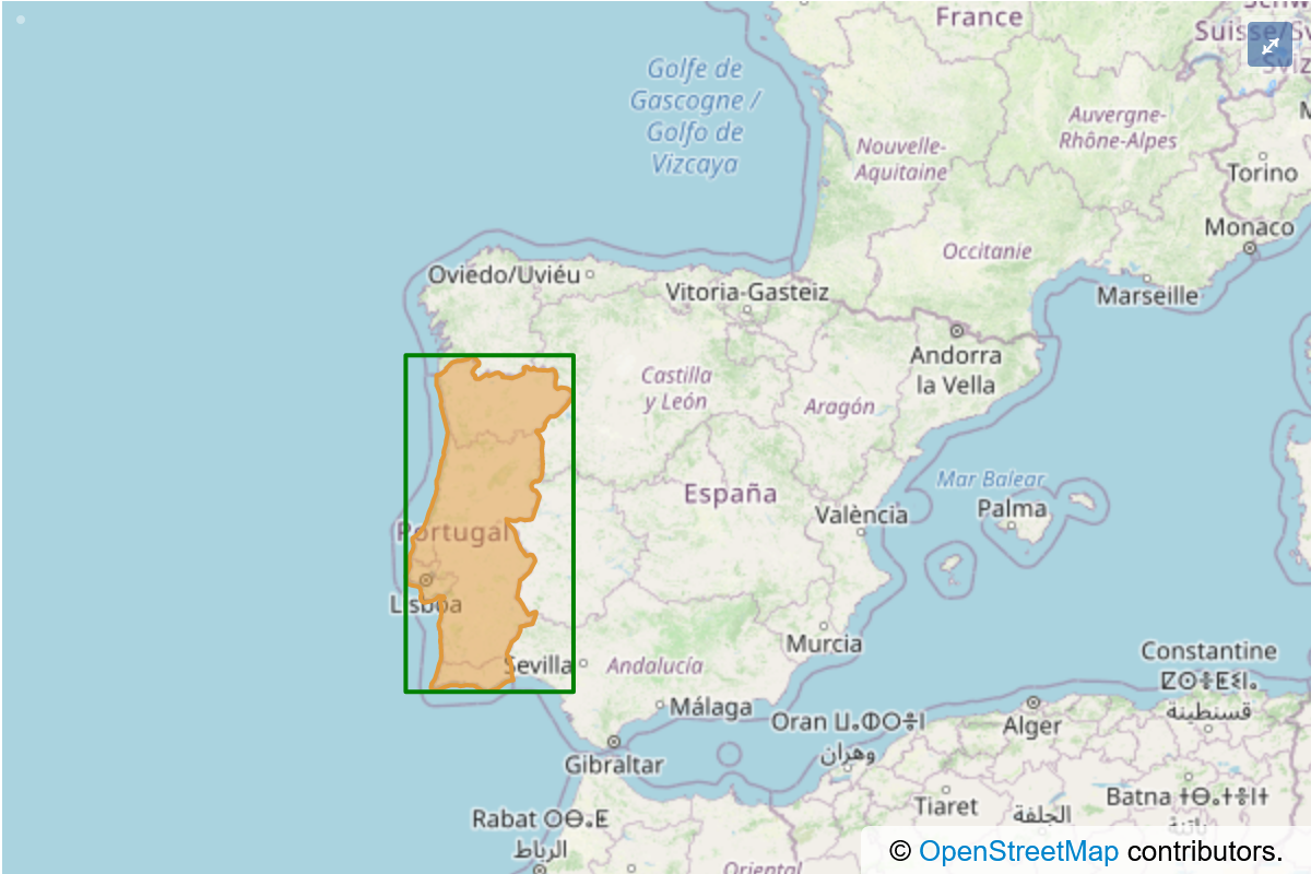
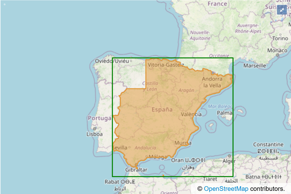
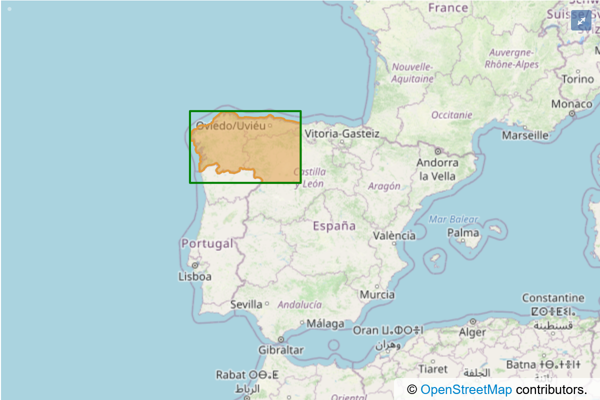
For a closer look at this, keeping the same example of ED50 to ETRS89, let’s consider the far-west of Europe (Spain and Portugal). Here, the relevant authorities have produced three distinct conversions, each for a different area. They are shown below in orange:


Even after deduplication, there are over 3000 distinct geographic extents required to support the full range of PHPCoord’s conversion abilities. Because borders are rarely straight lines, the full set of extent data for each and every coordinate system supported by PHPCoord would be over 100Mb of polygon data. That is far, far too much data to ask each and every library user to download and incorporate into their application.
Grids
For more modern coordinate systems it is becoming standard for mapping agencies to go beyond simply providing tailored parameters for broad regions or states within their territory and to provide detailed adjustments using a grid. For instance in New Zealand a 20km×20km grid provided by LINZ can be used to make significantly more precise conversions between NZGD1949 and NZGD2000. Using the grid provides for typical accuracy of ±0.2m, compared to a 4m accuracy from the alternative published transformation. For obvious reasons these grid files can also be quite large, and therefore the same concerns about packaging them apply.
“Out of the box”
The core PHPCoord package attempts to strike a pragmatic balance between accuracy and download size. It does not provide access to any grid-based corrections, and it uses simple bounding boxes (the green lines) as extent data rather than the detailed orange polygons.
As is obvious from looking at the Spain/Portugal images though, the areas enclosed by the green boxes have areas of overlap. In fact there are areas of north-east Portugal that are actually encompassed by all 3! If a coordinate is located within one of these overlap areas, then each of those 3 possible conversions is necessarily considered equally valid, and which one is ultimately utilised is undefined. The difference in resulting coordinate from any use of the “wrong” formula is likely to be very small (perhaps a few metres).
Note
This particular example was European, but “wrong” conversions can be picked wherever there are multiple extents for a given pair of coordinate systems. For example NAD27/83 conversions in North America, or SAD69 conversions in South America can be similarly affected.
Add-on datapacks
Not every user will consider the above tradeoff to be desirable, preferring instead to have the highest-accuracy conversions possible even at the cost of increased disk space.
PHPCoord supports this mode of operation via the use of optional add-on “datapacks”. These are additional Composer packages (8 available), each corresponding to a different region of the world:
php-coord/datapack-africaphp-coord/datapack-antarcticphp-coord/datapack-arcticphp-coord/datapack-asiaphp-coord/datapack-europephp-coord/datapack-northamericaphp-coord/datapack-oceaniaphp-coord/datapack-southamerica
Installing them provides access to the full-fidelity polygons for the relevant area of the world (at a scale of approx 1:15000000) and also any applicable grid files allowing PHPCoord to do the best possible job.
No configuration is necessary once installed.